Sponsored

"Adventure" Navigation?

kickstandsup

Member
First Name
Mike
Joined
Apr 21, 2020
Threads
2
Messages
12
Reaction score
21
Location
Tucson
Vehicles
Land Rover Discovery, Fiat 500, 4 motorcycles
Occupation
Retired
"Thanks to the interstates, it is now possible to travel coast-to-coast and see absolutely nothing." - Charles Kuralt.

Greetings all. I've got an R1S pre-order, placed in February just before the price increase...yippie! I'm hoping/guessing delivery sometime in 2024, which is perfect because my wife retires then and the R1S is a replacement for our LR Disco 2 as a travel/adventure vehicle.

I've watched many of the YouTube reviews, perused this forum and had a few "chat" conversations with Rivian customer service, all in an effort to understand whether the nav system will allow tertiary road routing or whether it is the typical on-board "point to point fastest route" system. Everything I see indicates it is simply point to point, with charge stations/requirements thrown in.

Is it only me, or does that seem utterly ridiculous for an "adventure" vehicle?

Perhaps my use case is unique, but this will be a "road trip" vehicle, and that means interstates when required, but tertiary roads when available, with some off road thrown in.

What I really want is to be able to sit at my computer, beverage of choice at hand, and plot the specific routes I want to travel, then transfer that route to the Rivian and have it add charge points/locations as required. All the Rivian nav system would have to do is accept a standard gpx file, then overlay the charging requirements. Alternatively, if Rivian wanted to build an app or web portal to do that, that would also work.

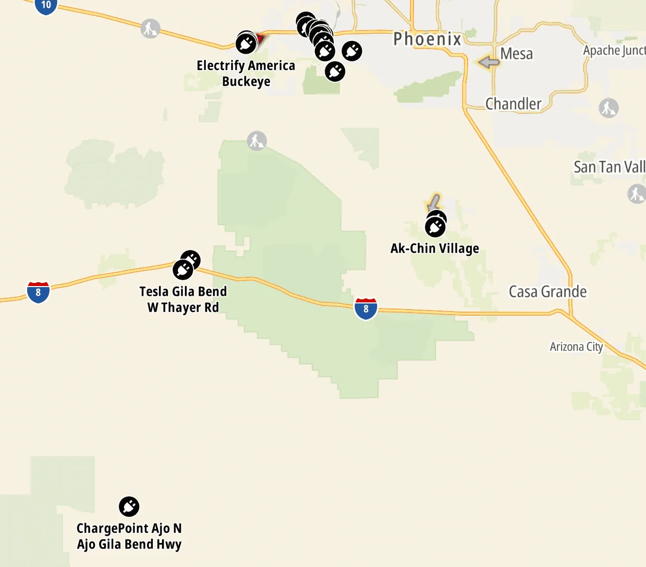
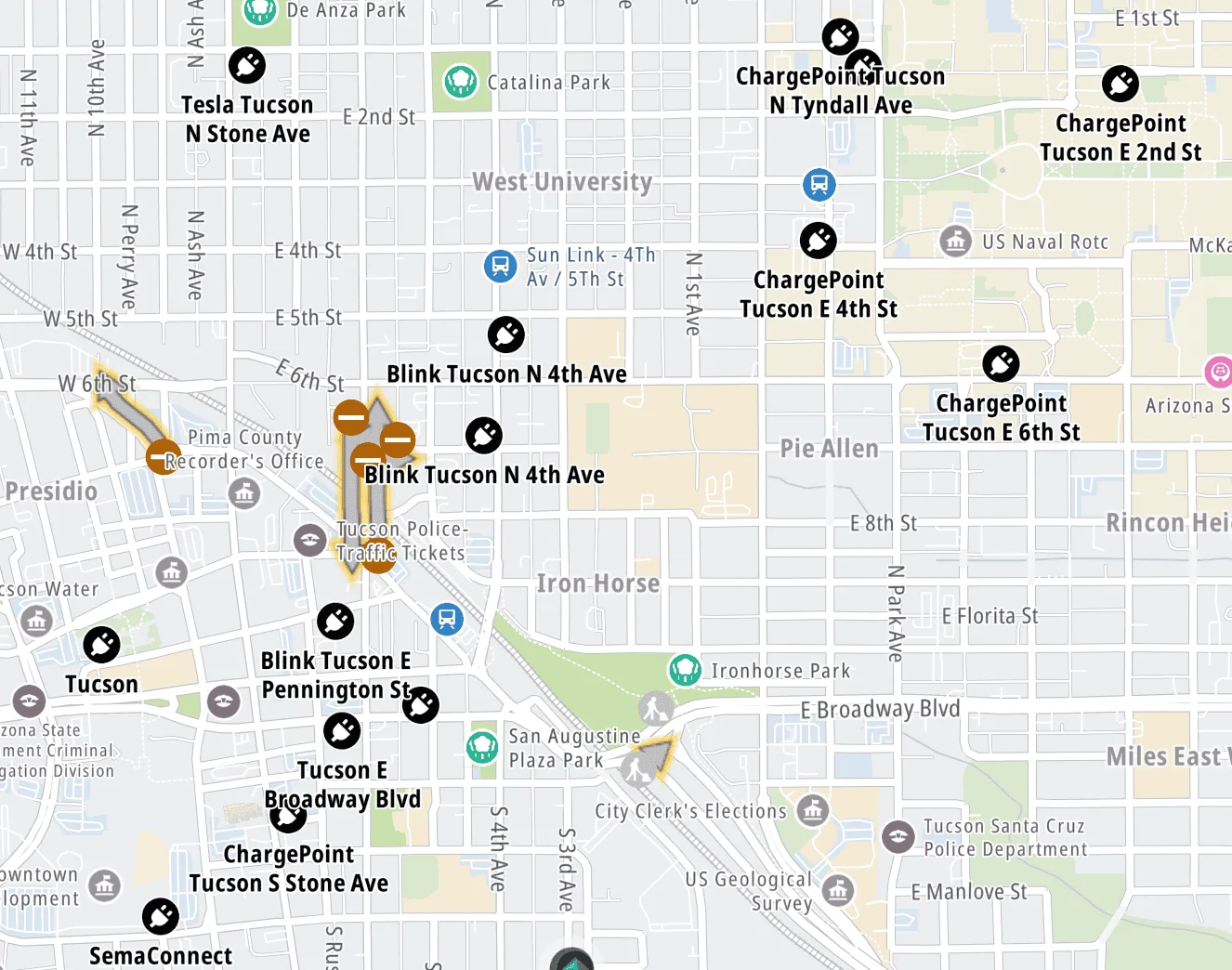
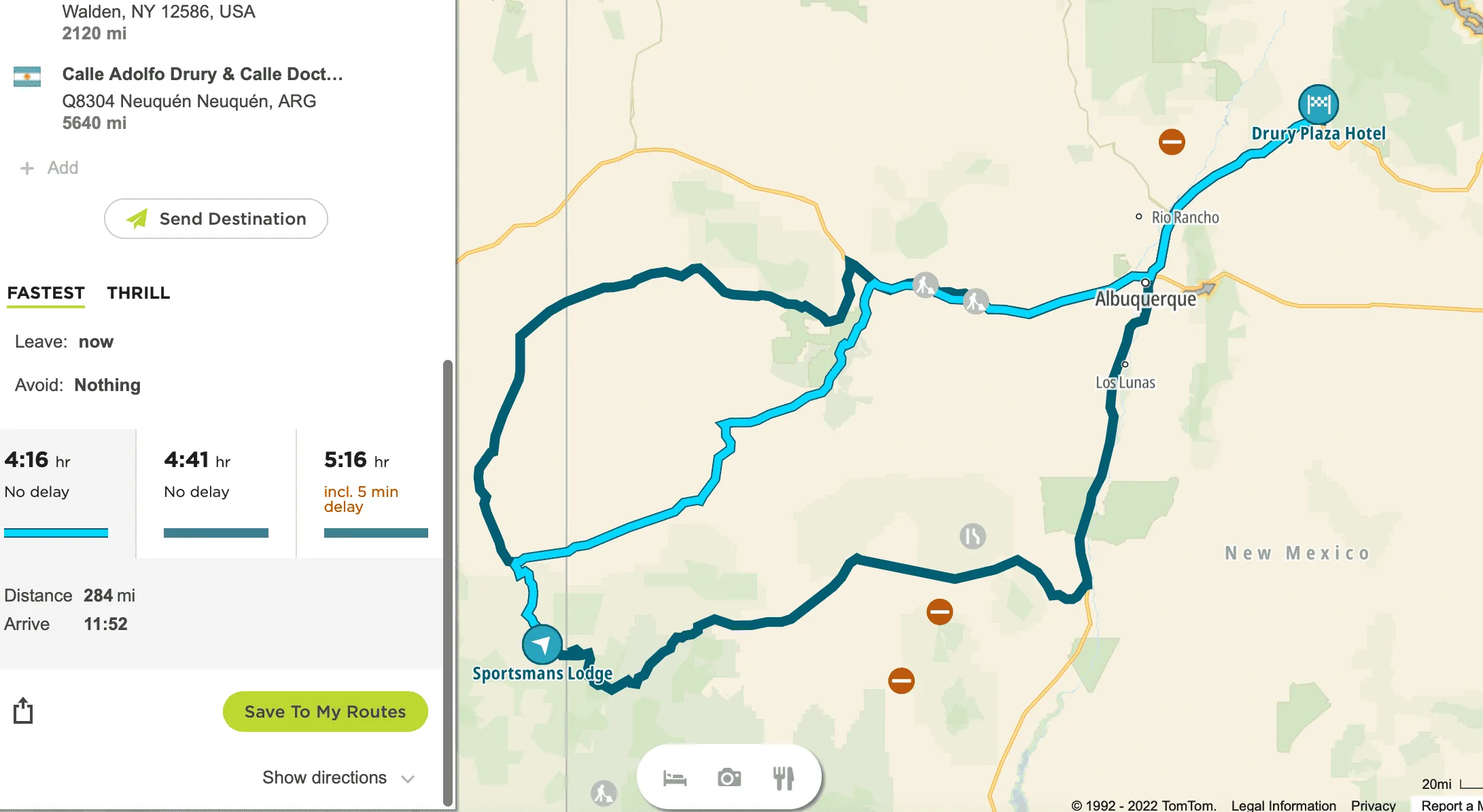
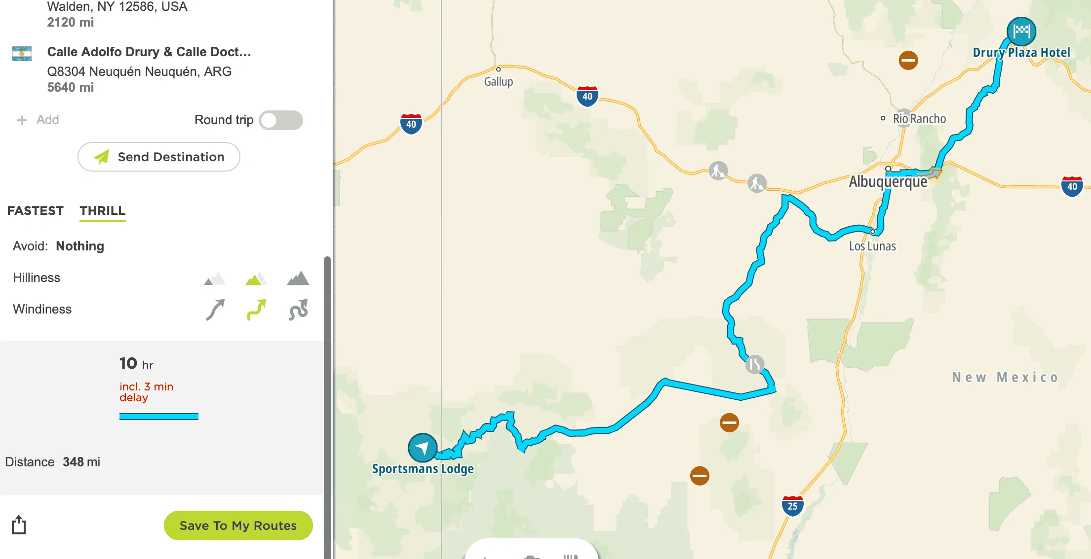
Right now, I use TomTom's MyDrive portal to easily plot any tertiary road route I want, and that wirelessly transfers to their sat nav device. https://mydrive.tomtom.com/en_gb/#mode=viewport+viewport=32.21626,-110.96405,13,0,-0+ver=3

For off road navigation, I've been using OnXoffroad, which generally works ok. https://www.onxmaps.com/offroad/app

What this allows me to do is at my leisure, and with lots of other info on attractions/restaurants/hotels at hand, plot a route that is interesting. The vey last thing I want to do is drone down the interstate and stop at Walmarts to charge.

To be fair, no other on board nav system does what I want either. But I'm surprised that given the intent of the Rivian, all the on board nav system seems capable of doing is taking you to a destination via the shortest/fastest route. A non-Adventure, IMO.

To be honest, I'm not yet sold on the Rivian as a good fit for our road trip vehicle. I'll need to drive it first, and see how the charging network develops over the next 18 months. I'm also not yet sure that any electric vehicle is a good fit for our purpose, given the charge times required. That said, I remain impressed so far and am hopeful.

But I really wish the nav was more adventure oriented. Am I alone in this?

Cheers!
Sponsored


ajdelange

Well-Known Member
First Name
A. J.
Joined
Aug 1, 2019
Threads
9
Messages
2,883
Reaction score
2,319
Location
Virginia/Quebec
Vehicles
Tesla XLR+2019, Lexus, Landcruiser, R1T
Occupation
EE Retired
Is it only me, or does that seem utterly ridiculous for an "adventure" vehicle?
Perhaps others feel this same way but I expect that most understand that it is what it is because that is how it will he used 99.9% of the time. The other 0.1%, i.e. where people will really be off road, they will use one of the common tools to get them to where they want to go off road and work with maps, GPS,... from there.

When you want to hit an out of the way spot the best way I have found to do it is to put a "waypoint" there in a program like ABRP which allows waypoints. Note that Tesla does not though Elon has been promising it for quite a while. Even doing this the result is not likely to be what you are looing for. A routing program works by optimizing with respect to some parameter or parameters. "Fastest" or "fewest miles" are easy to compute optimality criteria. "Most Scenic" is not. So it seems that to get what you want you are going to have to do quite a bit of manual work. The available programs will show you where the chargers are and you will have to fill in between them by hand. Keep in mind that the available programs are pretty confident about rolling resistance on major roads and can adjust for elevation change and even (ABRP paid version) weather to some extent. On logging trails all that goes away. You may be burning a kW/mi or more on some so be very conservative in planning charging and keep an eye on wh/mi as you go (Rivisn actually won't let you do that but you can convert from mi/kWh).
 

Dark-Fx

Well-Known Member
First Name
Brian
Joined
Jul 15, 2020
Threads
148
Messages
13,536
Reaction score
27,314
Location
Michigan
Vehicles
R1T, R1S, Livewire One, Sierra EV, R1S
Occupation
Engineering
Clubs
 
What I really want is to be able to sit at my computer, beverage of choice at hand, and plot the specific routes I want to travel, then transfer that route to the Rivian and have it add charge points/locations as required. All the Rivian nav system would have to do is accept a standard gpx file, then overlay the charging requirements. Alternatively, if Rivian wanted to build an app or web portal to do that, that would also work.
I think this is technically possible with the mapbox system they are using, but I'm not aware of how to do it ourselves. Would definitely make for a cool feature. If I want to force google maps into a particular route, I end up adding points of interest into the route. I haven't tried to do this in the Rivian yet as we haven't taken a road trip with it.
 

Neighbors

Active Member
First Name
Jason
Joined
Feb 28, 2022
Threads
0
Messages
27
Reaction score
41
Location
Lakewood, WA
Vehicles
2004 Prius
Occupation
Media Development
IIRC, very early on it was mentioned their nav would have prompts and recommended routes that were specifically scenic and adventurous. Obviously that's going to take a while to implement, but it's nice to know it's at least on their radar.

Way to make it in before the buzzer, and I hope your wait doesn't feel too long ;)
 
OP
OP

kickstandsup

Member
First Name
Mike
Joined
Apr 21, 2020
Threads
2
Messages
12
Reaction score
21
Location
Tucson
Vehicles
Land Rover Discovery, Fiat 500, 4 motorcycles
Occupation
Retired
IIRC, very early on it was mentioned their nav would have prompts and recommended routes that were specifically scenic and adventurous. Obviously that's going to take a while to implement, but it's nice to know it's at least on their radar.

Way to make it in before the buzzer, and I hope your wait doesn't feel too long ;)
Yeah, I felt pretty lucky to make it in under the buzzer...it at least should give us the option if it turns out we like the vehicle.

As for some type of adventure nav being on their radar, I'm not so sure about that. In the 2 chats I had with their customer service reps, both responded to my description with, "yeah, but how often will you do that?" For me, the answer will be "most of the time," but obviously they don't think that's true for their customer base.

And they may be right, I dunno. In car nav systems have always seemed pretty worthless to me for road trips, and it would seem Rivian's is no exception.

Interestingly, TomTom has recently added charge points into their mapping software, but it does not include (right now) any info on speeds, availability or number of chargers. I suppose I could plot the routes I'd like using this and one of the other apps that has more charge point information. Certainly not a seamless process and, like now, there's another device mounted in the vehicle.

I don't understand why in a "connected vehicle," Rivian or otherwise, the on board nav system can't accept a standard gpx file, which I can generate from the TomTom (or Garmin or others).

I simply don't want to have the tech dictate to me what routes I have to take; I want the exact opposite.

That's one reason why I posted here...if others' feel the same, perhaps raise the issue with Rivian because right now, I don't think they believe anything other than point to point, shortest distance navigation is necessary.

Rivian R1T R1S "Adventure" Navigation? Screen Shot 2022-05-16 at 6.16.10 AM


Rivian R1T R1S "Adventure" Navigation? Screen Shot 2022-05-16 at 6.15.23 AM
 

Sponsored

OP
OP

kickstandsup

Member
First Name
Mike
Joined
Apr 21, 2020
Threads
2
Messages
12
Reaction score
21
Location
Tucson
Vehicles
Land Rover Discovery, Fiat 500, 4 motorcycles
Occupation
Retired
Perhaps others feel this same way but I expect that most understand that it is what it is because that is how it will he used 99.9% of the time. The other 0.1%, i.e. where people will really be off road, they will use one of the common tools to get them to where they want to go off road and work with maps, GPS,... from there.

When you want to hit an out of the way spot the best way I have found to do it is to put a "waypoint" there in a program like ABRP which allows waypoints. Note that Tesla does not though Elon has been promising it for quite a while. Even doing this the result is not likely to be what you are looing for. A routing program works by optimizing with respect to some parameter or parameters. "Fastest" or "fewest miles" are easy to compute optimality criteria. "Most Scenic" is not. So it seems that to get what you want you are going to have to do quite a bit of manual work. The available programs will show you where the chargers are and you will have to fill in between them by hand. Keep in mind that the available programs are pretty confident about rolling resistance on major roads and can adjust for elevation change and even (ABRP paid version) weather to some extent. On logging trails all that goes away. You may be burning a kW/mi or more on some so be very conservative in planning charging and keep an eye on wh/mi as you go (Rivisn actually won't let you do that but you can convert from mi/kWh).
Perhaps, but just to be clear, I'm not talking only about "off road," I'm talking about tertiary paved roads, with some off road thrown in. Even if Rivian didn't do any off road navigation, the on board system should be able to handle plotting scenic, interesting, tertiary road routes, IMO. I don't want to road trip on only interstates, that seems pointless to me, especially considering the "adventure" nature of the Rivian.

TomTom, Garmin and others even have an automatic "curvy road" option. Put in a destination, opt for curvy roads and it will plot something interesting which you can then modify to taste. You can also put in "avoid" options, like highways, tolls, ferries, etc. This has existed for years, and should, at the vey least, be a "route option" in the on board Rivian nav system, IMO.

For example, using the TomTom My Drive portal, when you plot a point to point route, you usually get 3 options, similar to Google Maps.

Rivian R1T R1S "Adventure" Navigation? Screen Shot 2022-05-16 at 6.37.11 AM


But notice the "Thrill" option, if I choose that, it plots a much more interesting route.

Rivian R1T R1S "Adventure" Navigation? Screen Shot 2022-05-16 at 6.39.50 AM


And I can easily customize it further by choosing things to avoid.

I guess my point is that this has existed for quite some time and would be easy to incorporate in the on board system, or at the vey least be able to accept a gpx file.

This seems MORE important in an electric vehicle, given the charge point requirements, which are already a significant road trip obstacle.
 

Theeman

Member
Joined
May 10, 2021
Threads
0
Messages
19
Reaction score
36
Location
California
Vehicles
Highlander
Occupation
sales
You are right...why promote an adventure product (R1T) on the Trans-America Trail, that would require a second GPS unit or hard copy maps to navigate? The TAT website has the GPX files for sale. Allow us to upload files or download offline maps from a service. Seems like a missed opportunity.
 
OP
OP

kickstandsup

Member
First Name
Mike
Joined
Apr 21, 2020
Threads
2
Messages
12
Reaction score
21
Location
Tucson
Vehicles
Land Rover Discovery, Fiat 500, 4 motorcycles
Occupation
Retired
You are right...why promote an adventure product (R1T) on the Trans-America Trail, that would require a second GPS unit or hard copy maps to navigate? The TAT website has the GPX files for sale. Allow us to upload files or download offline maps from a service. Seems like a missed opportunity.
Exactly. You've got this giant screen that allows you to navigate from Walmart to Walmart on the highway. Dumb. And boring.

But like I said, no other manufacturer allows it either...so Rivian has an opportunity to further differentiate, by simply using what's been available for years.
 

Autolycus

Well-Known Member
Joined
May 2, 2021
Threads
15
Messages
2,234
Reaction score
3,430
Location
ATL
Vehicles
ICE only :(
I haven't really used it myself, but I've seen a lot of references to Gaia GPS. Having taken a quick look around their map, it'd be truly outstanding if Rivian would offer some sort of integration of Gaia's app.
Sponsored


Top