Sponsored
RAN Rivian Charging Stations Locations Map via Google Maps
BigSkies
Well-Known Member
Silverthorne will be a good addition. I've had mixed experiences at the nearby Walmart EA. No outright failures, just crowding and some slowish charging speeds. The Chargepoint at the Target up the road is a disaster.One great and one not-so-great sites planned in Colorado:
Centennial isn't a location I'd use, but I notice these chargers in denser urban areas are well used. They're probably the more profitable ones.
zefram47
Well-Known Member
- First Name
- Aaron
- Joined
- Feb 6, 2022
- Threads
- 18
- Messages
- 2,749
- Reaction score
- 4,511
- Location
- Denver, CO
- Vehicles
- Rivian R1T, Alfa Romeo 4C
- Occupation
- Software Engineer
Except that you have an 8 stall Supercharger just north of the Chargepoint and another 12 stall at the Frisco exit. Seems like an area that has a decent amount of charging already.Silverthorne will be a good addition. I've had mixed experiences at the nearby Walmart EA. No outright failures, just crowding and some slowish charging speeds. The Chargepoint at the Target up the road is a disaster.
Centennial isn't a location I'd use, but I notice these chargers in denser urban areas are well used. They're probably the more profitable ones.
VSG
Well-Known Member
So what?Except that you have an 8 stall Supercharger just north of the Chargepoint and another 12 stall at the Frisco exit. Seems like an area that has a decent amount of charging already.
I really don't understand the sentiment that Rivian should only be building DCFC chargers in the middle of charging deserts - far from traffic and power lines and other chargers, where they are also far from other Rivian chargers and extremely inconvenient/expensive to maintain.
There is no viable business model for this. That would mean giving up on the most profitable locations (which, by definition, probably already have chargers) and only building at the least profitable (or even operating loss) locations. That would be a stupid business decision.
EVs are an increasingly larger share of the vehicles on the road (in my county last fall, ICE sales were actually LESS THAN 50% of total vehicle sales!). That means we need more EV chargers where we already have other EV chargers. If these new chargers aren't earning Rivian money, then you're basically saying Rivian executives are idiots, and you can do better. Given Rivian's track record so far of creating an entirely new automobile manufacturer from the ground up, and succeeding far beyond almost every other new car company in the past 50 years, I highly doubt that.
Sponsored
Weekend at Gary’s
Member
- First Name
- Michael
- Joined
- Mar 29, 2025
- Threads
- 0
- Messages
- 13
- Reaction score
- 20
- Location
- Washington
- Vehicles
- R1S
I was pleasantly surprised to be routed to this RAN 2/6/26. There was a new Starbucks that seemed to pop up about the same time.Looks like the Ellensburg, WA RAN is open, according to the app.
BigSkies
Well-Known Member
Absolutely. EV sales were hovering around 30% for all of Colorado in the last year. There's a LOT of people that travel from the front range to summit county. It's a major travel corridor for both through-traffic and day trips.So what?
I really don't understand the sentiment that Rivian should only be building DCFC chargers in the middle of charging deserts - far from traffic and power lines and other chargers, where they are also far from other Rivian chargers and extremely inconvenient/expensive to maintain.
There is no viable business model for this. That would mean giving up on the most profitable locations (which, by definition, probably already have chargers) and only building at the least profitable (or even operating loss) locations. That would be a stupid business decision.
EVs are an increasingly larger share of the vehicles on the road (in my county last fall, ICE sales were actually LESS THAN 50% of total vehicle sales!). That means we need more EV chargers where we already have other EV chargers. If these new chargers aren't earning Rivian money, then you're basically saying Rivian executives are idiots, and you can do better. Given Rivian's track record so far of creating an entirely new automobile manufacturer from the ground up, and succeeding far beyond almost every other new car company in the past 50 years, I highly doubt that.
The next phase of DCFC deployments in CO is less about covering every city than it is about making sure there are enough chargers for all of the cars coming through. It sounds like WA is pretty similar.
trickyricky
Member
- First Name
- Rick
- Joined
- Oct 9, 2022
- Threads
- 1
- Messages
- 7
- Reaction score
- 9
- Location
- Lake Oswego, OR
- Vehicles
- R1S
This is really great work. I was also frustrated with the quality of the maps and data for RAN chargers. Since, I'm a software developer, I created a page that is updated every week and uses verified source data from Rivian. You can see my creation at https://rivianpoints.com/ran. Hopefully it's useful for someone. I use it for myself all the time now.The link below is to a Google Map that I have created with 3 layers. It is pretty raw right now, so I'll put all the information about it first. The link should stay good even as I try to polish things up over time.
I also can't promise that it will always be up to date. If Rivian changes locations on their map, well... those aren't going to be updated on mine because I won't necessarily ever learn that they've updated it, and too many updates will simply take time that I might not have for this project. If someone lets me know, I might be able to do one-off updates. If someone lets me know of major changes to the RAN map, I can probably do some bigger updates.
The 3 layers:
1) The RAN addresses that are "known" or guessed based on information in other threads in this forum -- right now it's the Salida, CO location and the locations shared for CA that were based on utility jobs involving PG&E.
2) Crudely-place points for RAN locations based on the Rivian.com map. They're crudely placed because all we can extract from the Rivian map is a fairly high-level of zoom with large icons. The icons appear to mostly be placed in the city or general area anyway. These are not exact locations and should only be treated as being within a 10-15 mile radius. They also don't reflect actual charging stations, just the areas that Rivian is loosely planning to put locations. I hope to name these points, but that's very time-consuming. A possible solution for that might be coming, and if it does will be reflected in an updated version of this layer. These points are based on the RAN map on 6/26/2021.
3) Electrify America locations I pulled from the National Renewable Energy Laboratory's data on alternative fuel stations, including EV chargers. This data is good as of 6/26/2021.
https://www.google.com/maps/d/u/2/edit?mid=1F-jpeAQfTwoHqy4dYtOStXLckGA714TJ&usp=sharing
If there are any features that people think are critical to this being usable, let me know and I can try to add them. Please keep in mind that some of this is time consuming and I do have a full-time job and other responsibilities and hobbies, so I make NO promises about adding anything or when it might happen.
If anybody is interested, I can share a geo-referenced TIFF file of the RAN map that I screen-capped from their website in pieces, stitched together, and then geo-referenced in QGIS. It can be opened in Google Earth if anybody wants to play with that at all. I can also share a KML file that has all of these unlabeled RAN points.
Finally, if automating the point names isn't doable, I will probably have to defer to others who are interested in crowdsourcing some of this. In that situation, I can share the map through Google Drive to let others edit. More on that if needed.
UPDATE (7/9/21):
1) I added a 4th layer: Rivian service and/or sales locations. I will start adding to it this weekend based on location information in this forum. (minor update 7/10: I added the ones that looked like very solid addresses from the thread on service centers and showrooms)
2) I am starting to add fields for additional data for each point, including status (permit, construction, online, ??). I will also try to have Google use different icons and/or colors for each status. It should work perfectly, but there are so few points with different statuses right now that I'm not 100% sure it will scale the way I expect. (minor update 7/10: I have also added a field for the source for the info, usually a URL to a RivianForums post or to a news article.)
3) Automating the point names for my "crude placement" layer was going to end up being trickier than the time it would actually save. I was able to churn out about 100 in an hour while watching tv (so not moving as quickly as I could with 100% attention). I will keep churning on that over time. Eventually I will get them all named, but honestly I don't think the names really matter all that much, so I'm not in a big rush.
4) I am going to look at some other options for this whole setup beyond just the basic Google My Maps. Those may allow a little more flexibility on crowdsourcing updated locations or status. "Free" is currently the most important criterion though, so I think it's going to stay where it is for now. The good news is that the data should be easily exportable from My Maps, so work done now won't go to waste if I change later.
UPDATE (12/10/22):
1) The layer for "target areas" now reflects 3 statuses: Open, Soon, and Other/Unknown. That will give an overall impression of progress and what's expected to come in the short and long term.
2) The layer with known addresses, including Open, Construction, and Permit will stay the same.
UPDATE (through 1/22/23):
TeamEV broke out the layers a little differently, which is an improvement for sure. There's still the original "target areas" layer. There's a new target areas layer that reflects the change on Rivian's site to show a more limited list of sites that are online or "Coming Soon". That way we can keep a bit of a "historic" record of the complete original plan while letting us focus on just the current version of the official map.
UPDATE (4/20/24): I pulled a new file from NREL and added it as a new layer. It's very messy, but you can at least get some idea of where each network has stations. If anybody has a good idea for how to relatively painlessly pull clean, complete data files as either CSV or KML for specific networks, especially Tesla (with the critical data on magic dock and NACS compatibility), I can try to do something a little better than this.
PROGRESS TRACK COMPARED TO TESLA SUPERCHARGER NETWORK:
Tesla Quarter Tesla Locations Open RAN Quarter RAN Stations Open Q4 2012 7 Q2 2022 3 Q1 2013 7 Q3 2022 ? (too lazy to look up when certain stations opened) Q2 2013 9 Q4 2022 9 Q3 2013 30 Q1 2023 20 Q4 2013 63 Q2 2023 38 Q1 2014 101 Q3 2023 52 Q2 2014 156 Q4 2023 64 Q3 2014 235 Q1 2024 71 Q4 2014 380 Q2 2024 82 Q1 2015 425 Q3 2024 Q2 2015 480 Q4 2024 Q3 2015 536 Q1 2025 Q4 2015 584 Q2 2025 Q1 2016 613 Q3 2025 Q2 2016 661 Q4 2025
And if you’re still reading and are planning to buy a Rivian, it’d be great if you use my referral code: THOMAS1811222
")
DuoRivian
Well-Known Member
- Joined
- Sep 3, 2023
- Threads
- 3
- Messages
- 1,592
- Reaction score
- 1,752
- Location
- California
- Vehicles
- Rivian R1T and an R1S
- Occupation
- IT
Great w
Great website, I was surprised when 350 sites located but it includes L2. 161 L3 is progress for Rivian.This is really great work. I was also frustrated with the quality of the maps and data for RAN chargers. Since, I'm a software developer, I created a page that is updated every week and uses verified source data from Rivian. You can see my creation at https://rivianpoints.com/ran. Hopefully it's useful for someone. I use it for myself all the time now.
Sponsored
jeeden
Well-Known Member
- First Name
- Jeremy
- Joined
- Oct 27, 2020
- Threads
- 57
- Messages
- 1,081
- Reaction score
- 1,632
- Location
- Northern VA
- Vehicles
- Rivian R1S, 2016 Ford Escape, 2015 Ford Mustang GT
- Occupation
- Project Manager
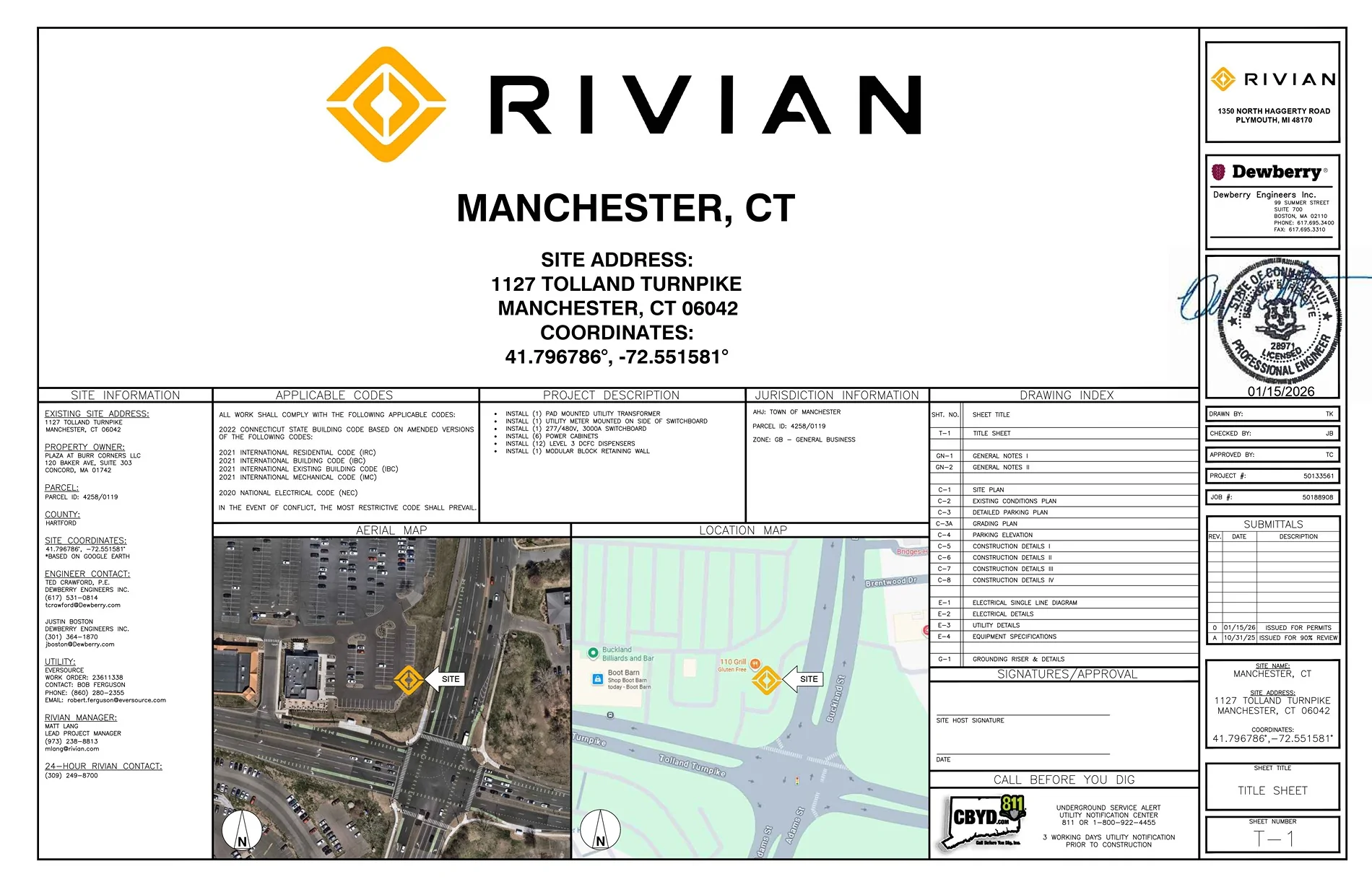
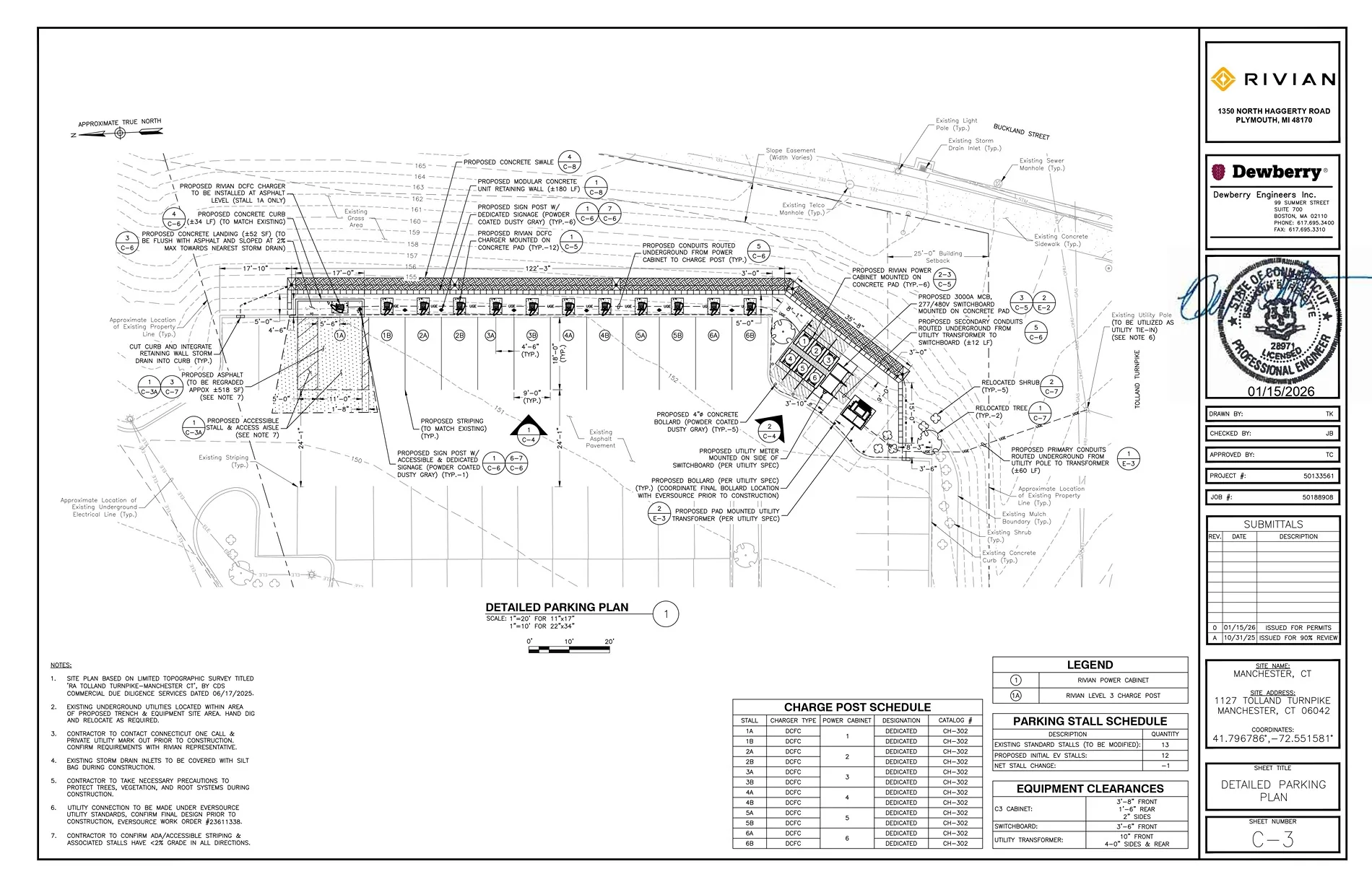
Great to see this. Hoping it is open by June for our summer trip from Northern VA to NH.Coming soon to Manchester, Connecticut.

trickyricky
Member
- First Name
- Rick
- Joined
- Oct 9, 2022
- Threads
- 1
- Messages
- 7
- Reaction score
- 9
- Location
- Lake Oswego, OR
- Vehicles
- R1S
It's also tracked here: https://www.rivianroute.com/ran/florida/west-melbourne-fl/West Melbourne, FL now under construction
trickyricky
Member
- First Name
- Rick
- Joined
- Oct 9, 2022
- Threads
- 1
- Messages
- 7
- Reaction score
- 9
- Location
- Lake Oswego, OR
- Vehicles
- R1S
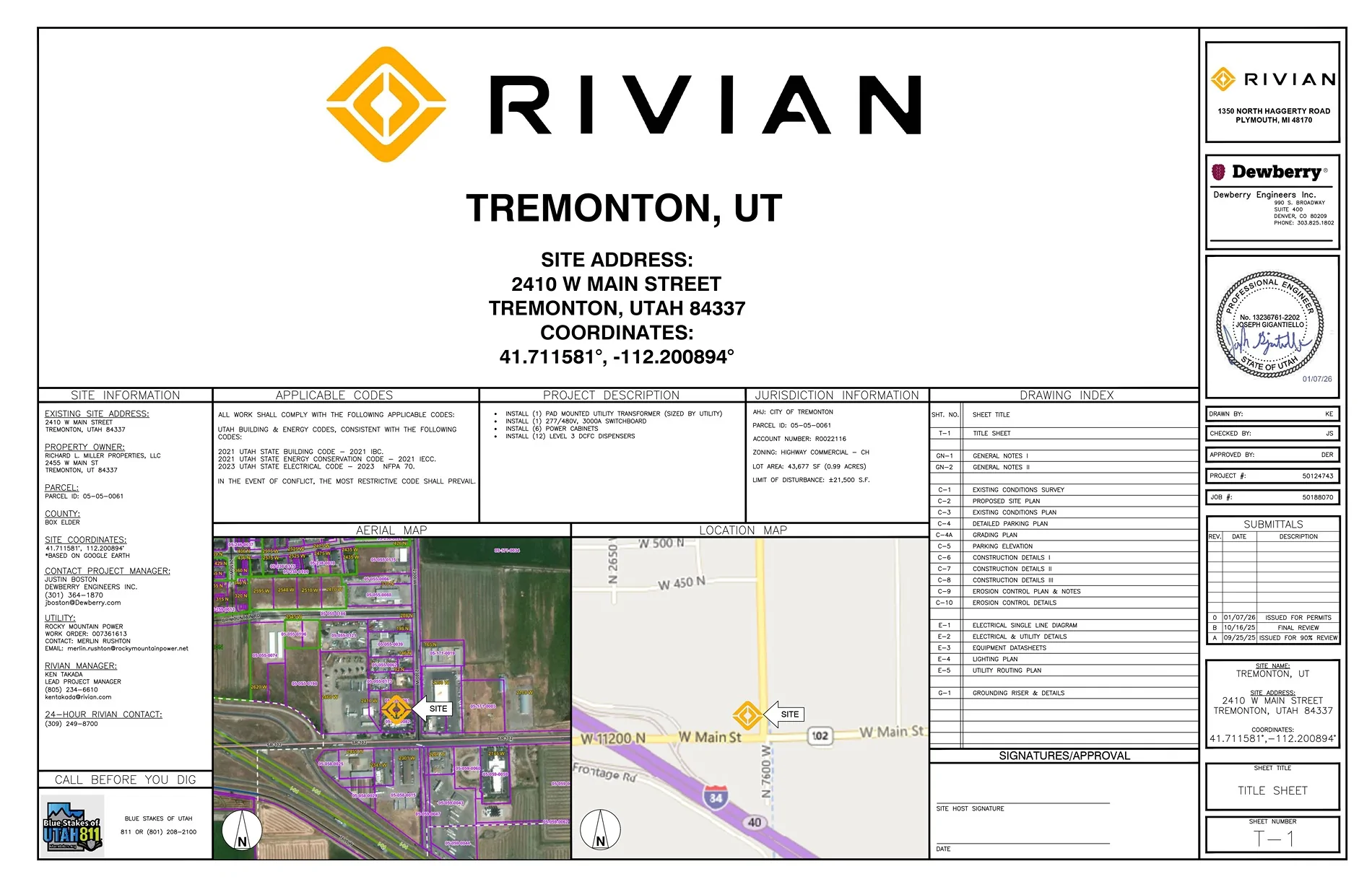
I will use this on my road trips to Utah! So, very glad to see this.Tremonton, Utah
I also track this here on my site. https://www.rivianroute.com/ran/utah/tremonton-ut/
Sponsored
Similar threads
- Replies
- 15
- Views
- 4,310
- Replies
- 51
- Views
- 4,400